

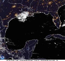
MIAMI (AP) — Tropical Storm Edouard was expected to strengthen significantly and possibly reach hurricane force Tuesday as it moved toward the Gulf Coast, where heavy rains and flooding were possible in parts of Texas and Louisiana, the National Hurricane Center warned.
The storm was upgraded Monday night from a tropical depression and forecasters expected it to make landfall in Texas later on Tuesday.
Tuesday morning, the storm was about 40 miles (64 kilometers) south-southeast of Cameron, Louisiana, and 70 miles (113 kilometers) east-southeast of Port Arthur, Texas, with maximum sustained winds of 40 mph (65 kph) while moving west-northwest at 8 mph (13 kph).
Tropical storm warnings, hurricane watches, storm surge warnings and flood watches were issued for the western Gulf Coast. The hurricane center said Edouard was expected to dump 3 to 6 inches (8 to 15 centimeters) of rain along the Texas coast through east-central Texas, but some areas could see up to 9 inches (23 centimeters). Southwestern Louisiana was expected to see lesser amounts.
Flash flooding was likely in low-lying and urban areas, the hurricane center said.
Texas Gov. Greg Abbott said the biggest problem expected from the storm is flooding.
“This is our first big storm of the season, and I’ll tell you, Texas is prepared,” Orlando Alanis of the Texas Division of Emergency Management said during a news conference.
Crews worked Monday to clear dry vegetation that could ignite from a lightning strike and cause fast-spreading fires, Abbott said.
Meanwhile, the remnants of Tropical Storm Dolly brought rain and thunderstorms to parts of Haiti and the Dominican Republic, the Turks & Caicos, and the Bahamas, the hurricane center said.
In the Pacific Ocean on Monday evening, Tropical Storm Lowell was about 630 miles (1,015 kilometers) southeast of Hilo, Hawaii, with maximum sustained winds of 70 mph (110 kph) while moving west at 10 mph (17 kph). Forecasters said Lowell could rapidly intensify and become a major hurricane by Wednesday.
Also in the Pacific, Tropical Storm Marie formed early Tuesday well offshore of southwest Mexico and wasn’t threatening land, the center said. The storm was about 470 miles (756 kilometers) southwest of Manzanillo with maximum sustained winds of 45 mph (72 kph) and was moving northwest. Marie was expected to become a hurricane in the coming days.
Elsewhere in the Pacific, Karina became a hurricane Sunday, fueled by warm waters far from any shore, and strengthened Monday into a powerful Category 4 storm. But it did not threaten land, forecasters said. On Tuesday morning, Karina remained a Category 4 hurricane and was centered 1,210 miles (1,950 kilometers) west-southwest of the southern tip of the Baja California peninsula of Mexico with maximum sustained winds of 140 mph (222 kph) while moving west-northwest at 10 mph (17 kph), the hurricane center said.
___
The story has been updated to correct that Dolly was a tropical storm, not a hurricane.
... Copyright © 1996 - 2026 CoreComm Internet Services, Inc. All Rights Reserved. | View our