

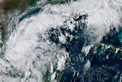
MIAMI (AP) — Tropical Storm Isaias formed early Wednesday in the warm waters off eastern Mexico and forecasters said it was expected to strengthen into the first hurricane of the Atlantic season before hitting the U.S. Gulf Coast later in the week.
The rapidly strengthening storm was on track to tie or break a 121-year-old record as the latest arriving initial hurricane of the Atlantic season. According to the National Weather Service, the record dates to 1905, when the year's first Atlantic hurricane formed on Oct. 8.
Isaias was centered about 285 miles (460 kilometers) west of Progreso, Mexico, and about 580 miles (935 kilometers) southwest of the Mississippi River’s mouth, according to the Miami-based National Hurricane Center. It had maximum sustained winds of 40 mph (65 kph) and was moving east-northeast at 8 mph (13 kph).
Forecasters predict Isaias will become a hurricane by Thursday as it turns northward toward the U.S. Gulf Coast. Though its path could shift, the storm is expected to make landfall late Friday or early Saturday between southeastern Louisiana and the Florida Panhandle.
The hurricane center said residents of the northern Gulf Coast should prepare for dangerous wind, storm surge and heavy rains that could trigger flash floods.
“It’s definitely time to look at your hurricane plan and put whatever you need into action,” said Eric Blake, a hurricane center forecaster.
Florida Gov. Ron DeSantis declared a state of emergency for 25 counties in the Panhandle and Big Bend regions. The declaration activates the state's emergency management plan for hurricanes, allowing officials to deploy disaster responders and equipment.
Isaias, (pronounced ees-ah-EE'-ahs according to the hurricane center), is forecast to dump heavy rainfall of 3 to 6 inches (8 to 15 centimeters) along the Gulf Coast beginning Friday, with some areas getting up to 10 inches (25 centimeters). Parts of the Southeast, as far inland as Tennessee and the Carolinas could see 1 to 3 inches (3 to 8 centimeters).
The storm comes as the Atlantic hurricane season has been unusually quiet this year due to a strong El Niño, which disrupts storm formation over that ocean. Storm activity in the Pacific has been above average.
... Copyright © 1996 - 2026 CoreComm Internet Services, Inc. All Rights Reserved. | View our